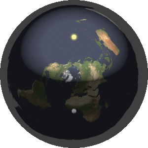
This Flat Earth Deception post shows that the supposed flat earth map with the rotating sun and moon, does not work in the real world.
This graphic of the sun and moon rotating above the flat earth looks cool, but this is not what we see when you look at the sun and the moon.
Let’s look at the location of the moon at sunset to see the relationship.
During the new moon phase, the moon is close to the sun in the western sky at sunset, and we don’t see any light on the moon.
Each day the moon ends up 12.2 degrees further away from the sun.
7 days after the dark conjunction, we see the 1/2 moon directly overhead at sunset.
14 days later the full moon is across the sky from the sunset, 180 degrees away from it.
The flat earth model has no way to show how the sun and moon move so closely together during the dark conjunction phase.
If they are on the same circular path as shown in the flat earth image, they would run into each other.
If they are on separate paths, where is that explanation on this supposed flat earth map?
Speaking of, that map that is show is a north-polar azimuthal equidistant project of the globe earth!
The map that flat-earthers use actually represents the globe earth!
Before computers, mapping out airplane flight routes was a challenge, as they had to use a globe, or images of the northern and southern hemispheres, like these.

To resolve this problem they created the azimuthal equidistant map, which allowed them to see all of the continents on one 2D map.
In order to do this, the bottom half of the globe earth had to be flared out into the outer circles. On the north-polar azimuthal projection map the northern hemisphere is shown in the inner circle, and the southern hemisphere is shown in the flared out circle that surrounds it.

These maps can be centered from anywhere. If you were planning flights from London, you would center it on London.
North-polar azimuthal projection maps were used during times of war, and the polar route is the shortest distance between countries.
Rendering a globe earth onto a 2D image always cause some distortion.
On the azimuthal projection map, the further away the land mass is from the center point, the greater the distortion. This is why Australia looks so wide, as it’s been stretched.
Since the continent of Antarctica is opposite of the North Pole on the globe earth, the only way to graphically represent it on the north-polar azimuthal projection map is by turning it inside out, and spreading it out as a white ring on the outside edge.
The South Pole is graphically represented by the outside line of the map.
You can see that the white ring has several bays that match up to the Ross Sea, which is close to New Zealand; and Weddell Sea, which is close to South America.
So the supposed flat earth map is really a globe map; and the sun and moon do not work properly on the flat earth model.
Read the home page: Flat Earth Deception