This website exposes the flat earth deception and proves that the earth is globe shaped.
This page discusses maps which prove that the earth is a globe, not flat.
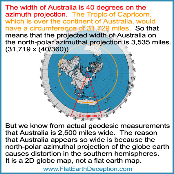
Question for flat earthers: How do you explain why the continent of Australia is distorted and appears to be 3,525 miles wide on the flat earth map, when we know from actual geodesic measurements that it’s 2,500 miles wide?
This is how the globe earth is rendered as a north-polar azimuthal equidistant projection.
They flare the globe out at the south pole. This is why the continent of Antarctica is radically distorted to look like a white ring.
Flat Earthers cite the Gleason Map as a flat earth map, but Gleason knew that it’s a 2D representation of the globe earth.
Sunlight on the Gleason flat earth map does not work properly.
Two excellent videos that demonstrate clearly why the Geometry of Sun angles make no sense on a Flat Earth but always work perfectly on the Globe.
The continent of Australia appears to be really wide on the north-polar azimuthal projection, because it distorts the southern hemisphere. This proof alone proves that it is not a flat earth map, and that it is just a projection of the globe earth.
The map that flat-earthers use actually represents the globe earth!
It’s a north-polar azimuthal equidistant projection, also called an azimuthal map projection. These maps can be centered from anywhere, but the north pole is the most common reference point.
You can make them on this Azimuthal Map Generator website, you just need to define the center point with longitude and latitude.
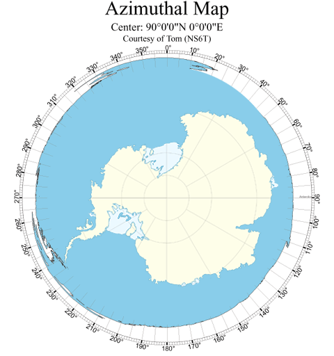
This is centered on the North Pole:
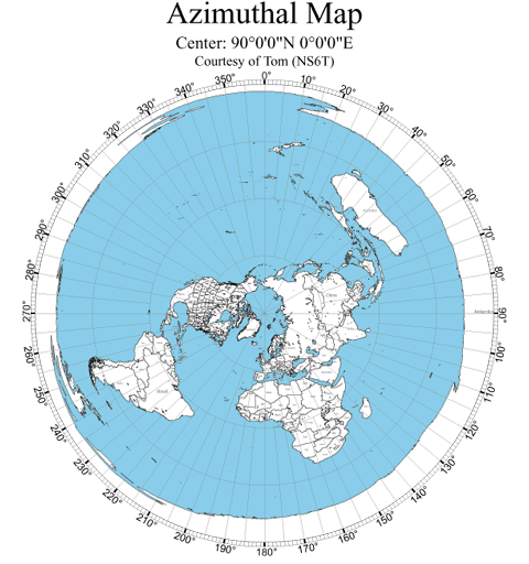
It is a projection of a globe earth onto a 2D map, that has straight meridian lines, with distances from the pole represented correctly.
It’s what you would see from the top of the globe earth, with the bottom hemisphere expanded out into the outer circles.
It’s not a proportionally correct map, as it exaggerates the size of countries in the southern hemisphere, as you can see with Australia, which is huge.
Australia is at the 45 degree south line, so on that map it’s twice the normal size.
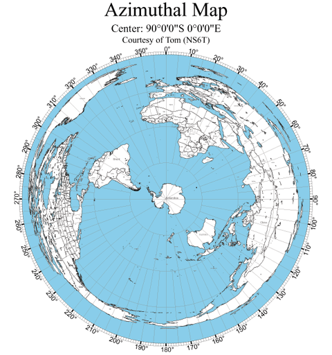
If the bottom of the globe was water, then the edge of the map would have just been blue.
Since the continent of Antarctica is on the very bottom of the globe, the only way to represent it on a north-polar equidistant projection map is to spread it out around the outer circle, as all of the longitudinal (meridian) lines point down to it.
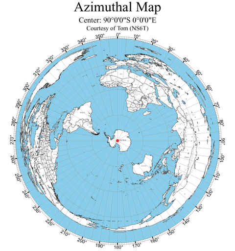
Here is one that is centered from the South Pole in Antarctica. You can see that the continents that are north of the equator are disproportionate. Note that Australia is correctly represented as it is close to Antarctica.
Here is one that is centered around the middle of the U.S., from Denver. Once again, the continents that are on the opposite side of the globe from the U.S. are disproportionately spread out in the outer circle.
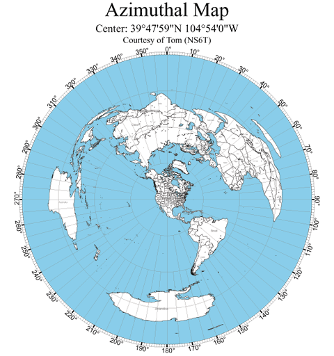
Now look back at the above projection maps that are based from the South Pole and America. Because there is no land mass directly opposite of the center point, there is no land ring on the outside of the circle. It is just ocean.
Now let’s look at the north-pole equidistant map again. As I previously noted, the white land mass that encircles the map represents the continent of Antarctica, which is distorted by the map being flared out.
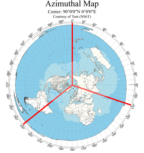
Every meridian line that originates from the North Pole runs down to the South Pole.
So on the north-polar azimuthal equidistant projection below, the red circle represents the South Pole, as all of the meridian lines connect from the North Pole to the South Pole.
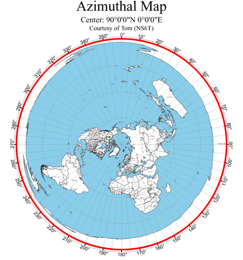
All of the meridian lines point down to the South Pole, which on this map is the red dot.
If you look at the land mass that encircles the azimuthal equidistant map projection, it is not uniform. The land mass is thicker on the right side. And there are some areas that are recessed.
That circular land mass is the continent of Antarctica spread out wide, and the .
Now look at this image that keeps the land mass around the outside edge, and has the continent of Antarctic in the middle, as that is what is on the bottom of the globe. The land mass is exaggerated, as the outside ring representation is exaggerated. The continent is inverted to match the inverted outer circle, as the equidistant view is from the top down.
Look at the left side of the continent, which is small compared to the right side. That matches the thin land mass of the left, compared to the right.
Now look at the peninsula on the left lower side at 240 degrees. It matches the peninsula on Antarctica.
The top of the circle is very thin and has a recess.
That matches the curvature of the top of Antarctica.
On the bottom right at 110 degrees, there is a small indentation.
That matches the bay on the southeast part of Antarctica.
Let’s take it one step further. The bottom left red line shows that the meridian lines runs from the bay of Antarctica through South America. The bottom left red lines shows that the meridian line runs from the small bay runs through Asia. The top red line shows that the meridian line runs from the other large bay in between North America and Russia.
The azimuthal equidistant map projection is only a tool, to help determine distances and flight maps on a globe earth.
Every time a flat-earther posts an explanation about direct airplane flights that they say is wrong on a globe earth; they are using this equidistant map, which is a globe map.
This Air Map Of The World from 1945 tells the truth, that the north-polar azimuthal equidistant projection represents a globe.
Notice that it doesn’t have an ice wall! That is because they didn’t include the continent of Antarctica, because it is so greatly distorted.
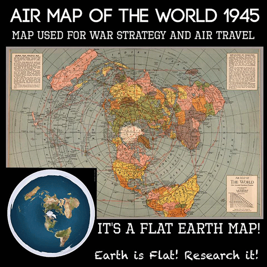
Here is the call out box on the top right:

It says “Since it is impossible to spread the surface of a globe on a flat surface without distortion, all maps are distorted in some respects. In this map the distortion occurs in the east and west distances. This distortion increases gradually from the North Pole to the Equator, and then quite rapidly to the outer limits. The distortion of the Antarctic areas would be so great that these are not shown.”
So they didn’t even include the supposed ‘ice wall’, because it’s not an ice wall; it’s the continent of Antarctica, which is greatly distorted by the algorithm used to make the projection map. Since Antarctica is opposite of the North Pole on the globe earth, the only way for the program to render it was to stretch it out as a circle. The outer circle is the South Pole. The continent has been inverted.
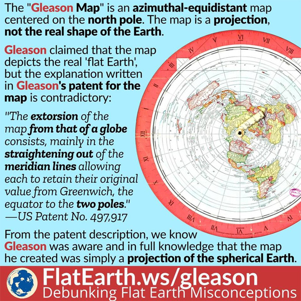
Flat earthers cite the Gleason’s New Standard Map Of The World as a flat earth map.
Alex Gleason wrote a book called “Is The Bible From Heaven – Is The Earth A Globe?’, in which he explains his flat earth theory.
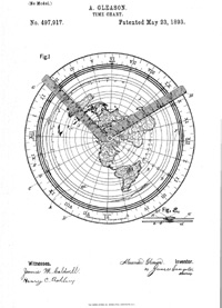
He applied for a patent for his map projection, which describes the map’s use as a time calculator for students. Here is what the patent image looks like, which has two hands on it, which spin around the north pole.
But the most important passage from his patent description is this:
“The map is not so extorted (distorted) as to lose the relative latitude and longitude of any places on the land or sea, but retains all latitudes and longitudes of places agreeing with other recognized authors; and as the proper relations of continents and countries all stand in their relative position to each other, they are thus impressed upon the mind of the student.”
Note: the words extorted and extorsion obviously mean distorted and distortion, as that makes sense when speaking about latitude and longitude on a projection map.
Alex Gleason is saying that the map projection has distortions; because is was derived from some other shape. That is what a north-polar azimuthal projection is, a projection of the 3D globe onto a 2D graphic.
“The extorsion (distortion) of the map from that of a globe consists, mainly in the straightening out of the meridian lines allowing each to retain their original value from Greenwich, the equator to the two poles.”
Alex Gleason proclaimed that it is a projection of a globe, which maintains the integrity of the meridian lines.
And note his phrasing “the equator to the two poles.” A flat Earth does not have two poles.
They cite that the U.N. mocks us by using a flat earth map.
Once again, it is simply a equidistant map, which represents the globe earth in a 2D format. How else would they, or anyone, represent the globe to show all of the continents in a 2D format?
Goofy flat earth explanations about Astronomy:
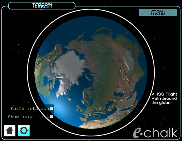
Here is their flawed explanation of the path of the International Space Station. There is no integrity with flat earth explanations like this. The map on the top is obviously not a good representation of a globe, as it’s a flat map with the countries side by side. The bottom image is a good representation of a globe, as it is a north-polar azimuthal equidistant projection map of the globe earth.
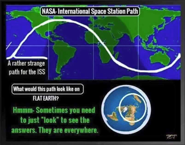
So they misrepresented the globe map, and then used a real globe map as supposed proof of the flat earth. Ya’ll need to wake up! The north-polar azimuthal equidistant projection map represents the globe earth. It is not a flat-earth map. By using that map you are proving the globe earth. Such irony!!!
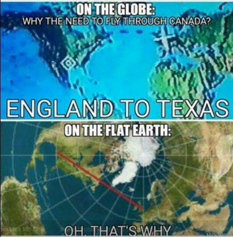
First of all, the image they use of the globe positions the two continents side by side, but they are on opposite sides of the globe, so it is a misrepresentation, which distorts the flight path going across the ocean. Of course, flight paths stay over land as much as possible for obvious reasons.
Then they use an equidistant map as their supposed flat earth map, to show the direct flight route. The anazimuthal equidistant map projection which shows distances and directions accurately from the center point. In this case, it shows the optimal flight path from England to Texas, which is direct and stays over land as much as possible.
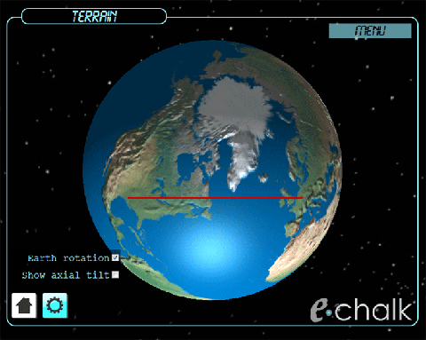
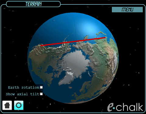
Here is the same flight path on a globe, which is the same as on the supposed flat earth map. You can use this echalk utility to see the direct flight path on the globe, which will match the equidistant map which the flat-earthers mistakenly use.
Here’s another example. Again the image on the left is a bad representation of a globe, and the image on the right is a globe equidistant projection map.
This all gets proved out with a picture of the flight on the globe earth
.
Flat earth believers make memes about flight paths using an equidistant map for their explanation. The irony is that is exactly what an equidistant map is for, as it represents the globe in 2D, to map out direct flights.
Here is a list of the types of map projections, of the globe earth.
Your talking about a map, but the truth is obvious when you observe reality. Alexander Gleason made a map on the 1800s that was as accurate is he could make at that time. There isnt an updated version because we are controlled by satanic pedofiles that want to hide creation and God from the world. Plenty of people have sent high altitude balloons up with cameras on them, forget about the curve and fish eye lens distortion, look at the sun really carefully on the videos. Observe its location on the way up, the hotspot reflection below, and the horizon behind the small local sun. An incorrect map made in the 1800s is not going to change my mind about the reality we live in which is obvious with a bit of research and some basic intelligence. Check out J tolan on YouTube using infrared photography. We live on a motionless topographic plane, there is no debate about it at all. Wake up. The truth will set you free.
Dave, it’s flat earthers who talk about the map, saying that it represents the flat earth, while the truth is that it’s a north-polar azimuthal equidistant projection of the globe earth.
You’re right that the truth is obvious, because every day the sun rises at full size from below the horizon, moves across the sky at the same size, and then sets at full size below the horizon.
That’s not possible if the earth is flat, as the sun would appear as a small dot above the horizon, grow dynamically in size until it’s overhead, and then shrink in size until it’s a small dot above the horizon. But that’s not what we see!
The truth set me free years ago, we live on a globe earth that’s at the center of the universe, and the evil ones have lied to the world about heliocentrism to promote their evolution doctrine. https://biblicalgeocentrism.com
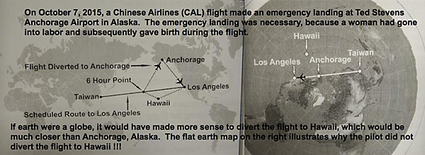
I guess if you’re scientifically illiterate, then you’re liable to conflate “proof” with “evidence” and commit all sorts of other logical fallacies along the way resulting in you being a Globe Earther. If you’re scientifically literate, however, then you’re simply gonna look at the available evidence (Google: “flat earth p900 cameras” or “16 Emergency Landings that Prove Flat Earth” or “200 Proofs the earth is not a spinning ball” if you don’t know where else to start, although I consider these “proofs” to be mere evidence open for debate, awaiting actual evidence of the globe, whereas typical mainstream NPC-type globe earthers only ever try and fail to “debunk” flat earth without actually bringing forth evidence of the globe) and looking at the evidence, you’ll see how flat the earth really is…
Dude, your comment is ignorant as I state on the top of the home page, “If you believe in the heliocentric universe, have you read what Moses, Job, David, and Isaiah; declared about the earth, the sun, and the stars? The Bible describes a sun that moves in a circuit, which has been stopped, and has been moved back. And it describes an earth that is fixed. The Bible is purely geocentric, and there is no Scriptural justification for the heliocentric model.”
I don’t talk about NASA or their fake moon landings on this website, nor do I believe that the earth is spinning.
So you calling me ignorant is ironic! 😛
Quick question… So H2o doesn’t seek LEVEL? explain how and for the love GOD don’t go GRAVITY on me lol… might as well say RUSSIA RUSSIA RUSSIA…
Ian, water, like everything else on earth is drawn downward, toward the earth. Whether that happens because of an electromagnetic force, gravity or an unknown force doesn’t change what we see. Water seeks to move to a lower elevation.
None of that proves that the earth is flat. It only shows that water moves from higher elevations to lower ones. The water collects in flat looking bodies of water, like lakes and oceans. But we can watch a ship move away from us and disappear after a few miles, due to the curvature of the earth.
That’s proved out on this page: https://flatearthdeception.com/ships-and-water-prove-the-flat-earth-deception-that-water-curves/
If you’re a flat earther, I challenge you to read the book and prove me wrong . .
Don’t have to you’re already wrong . .
Bro respectfully, research better.
Racer
You can try to prove me wrong by reading the book that you requested, but you since you think that you already know truth, you decline. Lame!
Physical reality debunks the globe. It is a fact earth is not a globe and has no curvature. Earth is flat. All the worlds oceans having no curvature destroys the globe.
Oh okay, thanks for letting me know. I’ll delete this website now that you’ve given such a convincing argument. 😛
The oceans have no curvature? That makes no sense. Why would the oceans alone have no curvature? Wouldn’t the land and oceans be together? There is land under the oceans. The oceans are vast areas that contain water. They are vast water basins. Day follows night with fixed regularity. This can only be done with the rotation of the Earth. How you could you make sunlight shine in one place and prevent it from shining elsewhere if the Earth is flat? Is there a giant holding a flashlight? Maps of the earth had to be flat for mathematical calculations. Otherwise it is too complex to calculate a straight line on a curve.
Thank you Anne for sharing your insight! Indeed, nighttime is only possible with a globe earth which blocks the suns rays from hitting the earth while still illuminating the moon.
You sure the sun illuminates the moon? Because that is what science tells you. I’ll go with the Bible on that one that it being a light on its own. Do the stars reflect sun also?
The oceans have land comment by Anne makes no sense.
Wes, the relationship of the sun and the moon is obvious, as we see the position of the moon in relation to the sun, which corresponds to the different phases of the moon. Since you don’t think that the sun illuminates the moon, please explain how the moon changes to display the different phases through a 29.5 day cycle.
If I was lied to in my schooling about God and the creation of His universe (which I was) and from whence I came, then I also have no problem questioning the globe-earth model. I tend to believe the globe-earth model as it seems to be the simplest explanation of how things work—and I cannot find Scriptural proof against or for either model. I voted for Trump; there was clearly election fraud; I love Christ Jesus. I have an easy time believing NASA is lying along with Hollywood, DC, London City, & the Vatican. Wouldn’t doubt it, but the Roman Catholics pushed very hard for the theory of flat-earth during Copernicus and scientist-theologians during the time gave up their lives to promote the globe-theory, which for them and their investigations, was Truth. Because they also were willing to die and go against the grain at the time, I am more inclined to believe the globe-theory. Also, I like this pages attempts to explain the distance issues that arise in debating this topic, as I have come often to the same points and was thinking of just getting a same-size flat earth map and globe to make the same comparisons. And yet, the flat-earth points—especially the dome issues, bring up interesting quandaries—but they could be answered by real atmospheric changes. After all of it though, and given what jobs God has given me to do, I believe we MUST ask Him for wisdom, “who gives generously to all without finding fault” (James 1:5). Does understanding the world as a globe or as flat-earth change that God is our Creator, and that He gives us loving limits? For me, no. He gives us rules to guide us and help us and keep us, like a Shepherd tends his sheep keeps them in the fold. May our Savior come quickly and show us all the Truth.
Thank you for sharing your perspective Emy! I believe that the enemy has created a false dichotomy between the heliocentric universe which allows them to push the evolution doctrine, and the flat earth theory to cause people to dismiss the geocentric universe design. The Bible describes a geocentric universe, but I don’t see it describing a flat earth with a dome over it. I cover the explanation of the geocentric universe in this free book: THE TRUE DOCTRINE OF THE GLOBE EARTH – A SCRIPTURAL VIEW OF THE UNIVERSE
Keep learning and growing in The Way! 🙂
I mean, this is a regurgitation of 8th grade geology class. I don’t trust the government or satanic scientist paid by the government, I don’t know how the Earth is shaped and neither does the author of this page. I don’t understand why people get mad at us for questioning popular belief. I think people who blindly believe everything taught to them or use second hand accounts as facts. The globe earth wouldn’t stand as a defense in court. I haven’t been to space neither has the author, you can’t prosecute a flat earther because you and a majority of people believe it’s round because you were taught that in school or because NASA tells you that. If you haven’t been up there, then you don’t know what shape it is just like if you didn’t see the crime happen you can’t sue someone for theft because you herd a rumor. The globe is a rumor. NASA took over 30 years to compose a picture of earth from space, which is really a artist rendition of data. Yet NASA always has these new photos of far out planets they discovered. So they can take real photos of planet xx123456890 but earthis a nearly 40 year task of collecting data and having an artist animate it. Also the US Navy had missions that went past Antarctica, World beyond the poles has the mission details of it. Operation Fishbowl by the US Air Force which I served in, had nukes shot directly up into the sky, they all blew up at the same height and nukes need a hard surface to detinate them. We used flat Earth maps in the AF for ground missions because it accurately shows points of direct distance which is critical in mission planning. You guys believe the moon landing, dudes used a giant Erector set model to go to the moon, how did they live broadcast from the moon 50 years ago when if it rainsbtoday my direct TV goes out. Lol. You can’t get reception in the forest on your phone but they can broadcast from the moon. Lol man I should be angry at you. You probably believe Biden beat Trump and there was no fraud, that’s because mainstream media says so, not the electoral college nor Senate but TV told you, so it’s facts. You can research yourself but why, TV is easy and doesn’t lie. You see what I mean, you guys are assholes about this, I’m not stupid because I don’t believe this crap, I got legit reasons. Not copy and paste textbook crap. Maybe I’m just different, Black man, no prison, veteran, college, married, all kids in wedlock, Trump supporter, hates BLM, believes police shootings are staged psy-ops, maybe it’s me.
cool a lot of information i need to review.
I believe the earth is flat because that is what is consistent with the Bible. Plus also it is from my own observations and that it also makes sense to me. For the avoidance of doubt, the flat earth is centred on the so-called North Pole, so it is the Azimuthal Equidistance rendering of the earth where the center is 90 degrees North and the East is 0 degrees. Any other rendering with different coordinates is not the flat earth representation.
In the meantime, I have some questions I would like you to answer please:
1. Show from the globe earth the flight path from Johannesburg (South Africa) to Buenos Aires (Argentina) or Santiago (Chile). It should look like an inverted V (data from flightradar24 mysteriously goes missing once the aircraft hits the sea, if you can find the flight path of the aircraft over the sea I would greatly appreciate). There were times when these flights would do a stopover in Dakar (Senegal) for refuelling before proceeding to South America. Jo’burg – Dakar – Santiago would not make sense on a globe earth but only on a flat earth.
2. Earth is not a globe, it is pear shaped. This is according to Neil deGrasse, the astrophycist authority on round globe/oblate spheroid/pear shaped. (https://www.youtube.com/watch?v=SoCKapivHGM) See from 1:19. So if the earth is pear shaped, and the Bible says that God sits above the circle of the earth, this means one of two things: That God is sitting above most of Europe/Russia, which means Africa/South America/South East Asia are the stomach/gluteus maximus of the earth and Antarctica is the foot, or that the God sits above Antarctica which still means Africa/South America/South East Asia are still the tummy/backside of the earth and Europe/Russia is the foot. Since there’s nothing in Antarctica, it seems highly likely that God sits above Europe. (Any other bird’s eye view of the earth other than 90 degrees North or 90 degrees South would not produce a circle on an oblate spheroid or a pear-shaped earth). So Europe then is where God’s throne is situated at? I do not think so. But on a flat earth, God would sit above the circle of Antarctica which means He sees the whole earth at the same time, which is consistent with God’s word that His eyes search to and fro over all the earth.
3. If the pear-shaped earth is spinning a complete revolution on its own axis every 24 hours, how is gravity a constant? The centrifugal forces at the equator cannot be the same as the centrifugal forces at the North and South Pole (which at these two points the spinning is zero hence zero centrifugal force). How is the force required to keep things grounded at the equator the same as the force needed to keep things grounded at the North/South Pole?
4. Does the atmosphere spin with the pear-shaped earth? If it does, the heavier gases should be flung outward towards space/edges of the atmosphere while lighter gases should be at the surface of the earth. If the atmosphere does not spin with the earth, then we should have a dust storm of apocalyptic proportions at the point the atmosphere touches the earth. But we know the atmosphere thins out evenly as one goes up, keeping its gaseous ratios constant. This is consistent with a stationary earth and stationary atmosphere but not possible on a pear-shaped earth.
5. There are many other pointers I could reference, but I will finish – without quoting unless you want me to – the numerous verses in the Bible that are only possible in a flat earth. Christ when He returns, He will be seen by everyone at the same time. Not possible on a spheroid. Bible talks of corners of the earth, not possible on a spheroid, Joshua prayed and the sun and the moon stopped, in a spheroid earth, it is the earth that should have stopped because the sun is stationary, only rotating on its axis. And then there are the numerous verses that say the earth is firmly grounded, it shall not be moved. But the spheroid moves in two ways quite actually – about its own axis and also around the sun. This is in complete contradiction of what the Bible says about the movement of the earth.
I pray that as you answer these questions, you do so with an open mind because some of us were more staunch globe earthers and fought valiant battles in defence of the globe until we saw the light. I nevertheless believe in due time the whole world will come the full circle and appreciate that Heaven is God’s throne and Earth is His footstool 🙂 Allow me to finish by saying: If you choose to believe that God created a globe for you to live on, then glory to Him who made the globe. If you, like I, choose to believe He made a flat earth for us to dwell upon, then glory to Him who made the flat earth. Let this not be about who’s right and who’s wrong, but rather that whatever we believe the shape of the earth is, it is created by God, even though it is harder to believe God made the earth as a globe because it contradicts so many ‘earther’ scriptures 🙂
James, I don’t debate the physics of this earth and universe, as each side sees what they want to see, so it’s a waste of time. As for what the Bible says, I wrote a book that covers the verses that flat earthers cite, so there’s no need to debate that either. Some of your points are about a spinning earth, which is odd because if you read my website or book you would know that I believe that the earth is at the center of the universe and not spinning, and that the sun moves in a circuit around the earth.
Earth WAS .. IS .. AND ALWAYS WILL BE FLAT .
Your website is total crap and has nothing to do with science or common sense all you’re doing is mocking flat earthers for having the reasonable sense of actually doing somr research and finding the truth themselves instead of blindly following with NASHOLES at NASA are telling them like sheep.
As usual, a flat earther is making statements, but not proving my explanations wrong. You say it has nothing to do with science, but it cites the Michelson-Morley and Airy’s Failure experiments, which prove that the globe earth is not moving.
You cite the lack of common sense, but you can’t see that the sun and moon stay the same size all the way across the sky, which proves that the earth is not flat.
Then you cite NASA, which I don’t use for any proofs on this website.
EPIC FAIL!
You show the flightpath of the space station????? Newsflash, there isn’t a space station. Do some research on that. Everything NASA says is a lie including there fake space station.
Wes, the meme with the space station is a flat earther meme. I used it to show how absurd their explanation is, as it uses a Mercator map which has the countries side by side, to proclaim that the flight of the space station doesn’t make sense on the globe. SMH!
Your imaginary Earth is as flat as your brain.