This website exposes the flat earth deception and proves that the earth is globe shaped.
Flat earthers make claims about airplane flight patterns, but their explanations use a north-polar azimuthal equidistant projection of the globe map.
For example, a flat earther recently said that his wife travels once a year from Los Angeles to Shanghai always flying over Alaska and the North Pole where instead on the globe the shortest route would be over the ocean.
Of course that statement is ignorant, as airlines avoid flying over the ocean when possible, in case of an emergency.
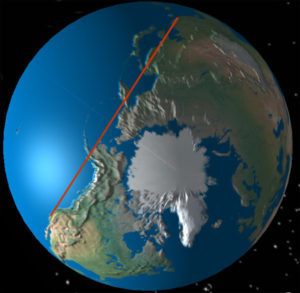
Here’s a direct line over the ocean:
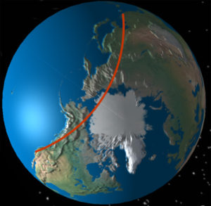
Here’s a more logical flight path which keeps the airplane over land for most of the flight; and flies over Alaska.
You can use this eChalk interactive tool to see how flights appear on the globe, so that you can try to prove out your explanations. If you’re seeking truth, then you’ll see the fallacy of the flat earth explanations regarding flight patterns.
Flat earthers post images of flight patterns, which seem to show that flights are fairly direct on the supposed flat earth map. You can see the matching Mercator map and the flat earth maps.
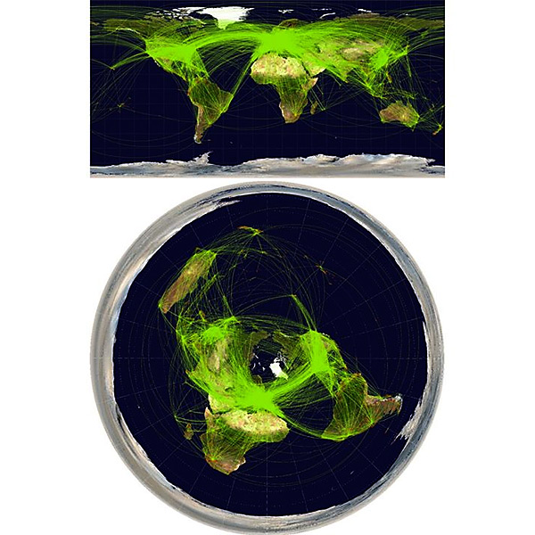
Your eyes are drawn to the flights in the central areas, which appear to be fairly straight. But it seems that flat earthers intentionally make the image dark, so that you don’t notice the Southern flight routes, like they are trying to hide them.
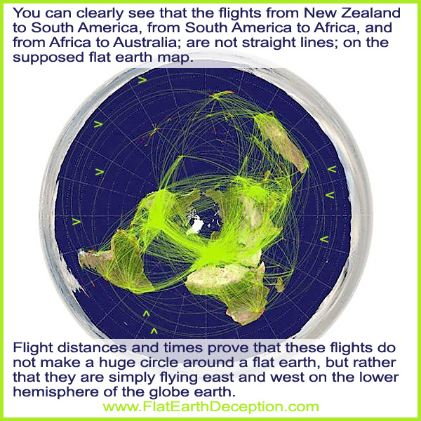
When you lighten up the image, the Southern flight routes are easier to see, and they show the exaggerated curvature of the flights on the supposed flat earth map.
It’s ridiculous to think that airplanes travel those extra miles and even fly in the supposed forbidden Antarctic zone. All of this proves that the flights are flying in straight paths from southern continent to southern continent on the globe earth.
 Flat earthers like to post images of flight patterns on a equirectangular or Mercator map, saying that it represents a globe earth; but placing continents side by side obviously does not represent the globe earth.
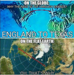
Then they use a north-polar azimuthal equidistant projection as their supposed flat earth map, to show the direct flight route. The azimuthal equidistant map projection is a 2D globe map, which shows distances and directions accurately from the center point. In this case, it shows the optimal flight path from England to Texas, which stays over land as much as possible.
.

All they had to do was map out the flight on an actual globe, and they would see that it matches the azimuthal equidistant map projection, which is a 2D globe map.
Here is a link to a page where you can map out airplane flight start and stop points, to see it on a north-polar azimuthal equidistant projection, which is mistakenly called a flat earth map; and on a globe; to see that the flight patterns are the same.
https://www.metabunk.org/flat/
Here’s a link to a page that calculates distances on the globe earth and flat earth models, to compare them.
http://walter.bislins.ch/bloge/index.asp?page=Distances+on+Globe+and+Flat+Earth
A commercial pilot who is based out of Australia, who makes international flights in the southern hemisphere, shows that flat earthers cannot produce a legitimate pilots flight plan.
The video description says: A message to Flat Earthers. If you can’t show me a map that works and you can’t tell me how to navigate precisely around the real Earth you are wasting your time telling me the Earth is Flat. I can and do navigate precisely around the real Earth and I have been doing this safely for over 30 years using the Globe. Time to start producing real results guys. The same old nonsense arguments won’t cut it here any longer.
Flat earthers were challenged in December, 2016; to map out a flight plan, but nobody has done it.
The challenge is to produce an accurate distance between Sydney and Tahiti airports with a number of waypoints spaced every 500 nautical miles along the route.
Provide the precise latitude and longitude of these waypoints and the direction between each point.
You must demonstrate that the distances and directions are calculated using two dimensional math on a Flat Earth.
Flat earth commercial pilots are welcome to contact Wolfie6020, to discuss how they plan out their flights on the flat earth.
He prefers to talk to ATPL rated pilots, as they are the ones who have to put together flight plans for intercontinental flights.
Click here to link to the page where you can connect with Wolfie6020.
Airplane flights in the Southern Hemisphere prove that the Earth is a globe, and not flat.
All you have to do is use a flight tracker like Flight Aware, to see the length of time of miles, of flights in the Southern Hemisphere; to see that it’s impossible to fly that distance on a flat earth.
Here is a flight from Perth, Australia to Johannesburg, South Africa.
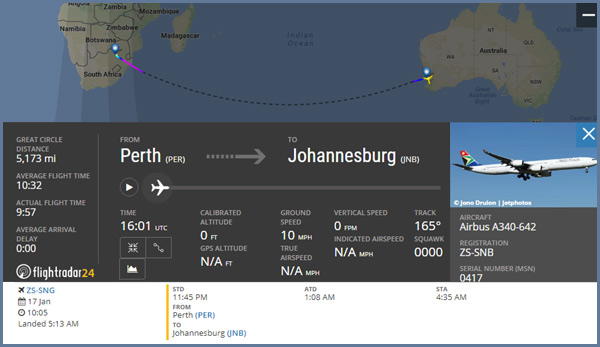
Flight Time: 9 hours 57 minutes. Distance: 5,173 mi
It is impossible for this flight to be made in that amount of time, and that short of a distance, on a flat earth!
Here is the page that lists flights from Sydney, Australia to Johannesburg, South Africa; that take place regularly..
Here is a flight from Auckland, New Zealand to Santiago, Chile.
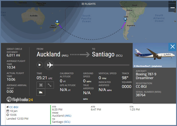
Flight Time: 10 hours 06 minutes. Distance: 6,011 mi
Here is a flight from San Paulo, Brazil to Johannesburg, South Africa.
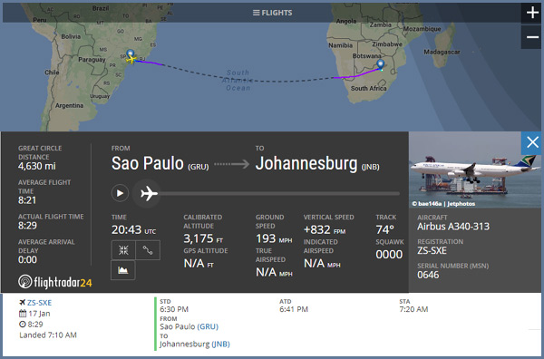
Flight Time: 8 hours 29 minutes. Distance: 4,630 mi
It is impossible for those flights to be made in that amount of time, and that short of a distance, on a flat earth!
Here is a link to a page where you can map out airplane flight start and stop points, to see it on a north-polar azimuthal equidistant projection, which is mistakenly called a flat earth map; and on a globe; to see that the flight patterns are the same.
https://www.metabunk.org/flat/
Unable to debunk the flight times and miles, flat earthers proclaim that these flights aren’t real.
Here’s Wolfie6020 showing you passengers getting on board flight QF27, which goes from Sydney to Santiago
Analyzing aircraft Flight Paths correctly. Flat Earth or Globe? Where do they make sense?
East and West curve on the flat earth model.
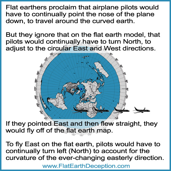
Flat earthers ignore that when traveling east or west, they would have to continuously be turning around the curved flat earth.
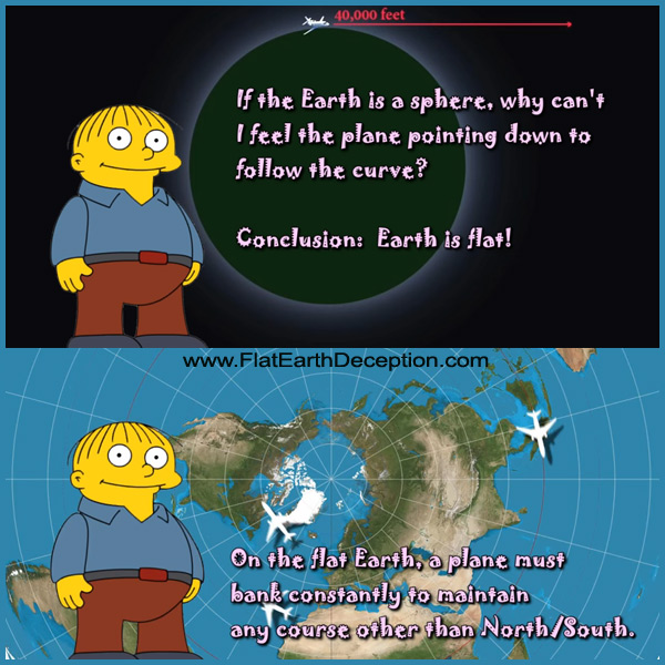
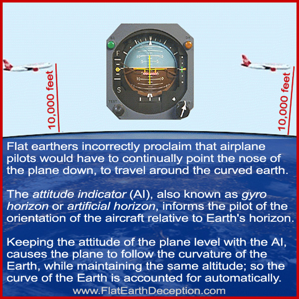
Flat earthers say that airplane pilots would continually have to point down, to curve around the globe earth.
Of course that is absurd, as the natural tendency of a plane is to point its nose down; so in reality, they are having to keep the nose up to maintain altitude.
Flat Earth vs Globe – Understanding Aircraft Emergency Landings correctly.
.
Return to the Flat Earth Deception home page