This website exposes the flat earth deception and proves that the earth is globe shaped.
This page provides proof that satellites exist, which is contrary to what flat earthers say.
At the FE2018 conference, Rob Skiba said that he believes in satellites, and that he used to install them. But satellites are geostationary or geosynchronous around the globe earth, so there’s a disconnect in Rob’s brain.
They proclaim that there are no satellites, and that communication is done through cable or towers.
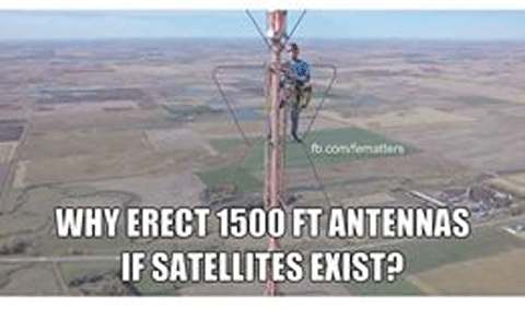
The answer to the question is that satellite communication has to overcome distance and can be affected by weather, so they erect towers to provide better communication over a localized area.
Inmarsat is the leader in global mobile satellite communications. Thousands of vessels rely on our unrivalled end-to-end service availability and coverage for operational communications and safety services.
This time-lapse of the International Space Station transiting the sun proves that satellites exist.
Flat earthers proclaim that satellites don’t exist, which is absurd, given all of the weather satellite images of hurricanes lately.
Reds Rhetoric uses a Nikon P900 to capture an ISS Lunar Transit
John Michaelson took advantage of the ISS passing overhead near where he lives, and captured it transiting the sun. He didn’t do it to prove that the ISS exists, but simply for the challenge of capturing it on a video.

Flatearthers must deny the existence of satellites, because satellites cannot orbit a flat earth.
So, they invent other ideas for how GPS / GNSS works, mostly involving antenna towers on the ground. This seems to satisfy large numbers of people that accept this flat earth claim made without knowing anything about how GPS / GNSS really works.
WGS84 is standard for GPS
The World Geodetic System (WGS84) is the reference coordinate system used by the Global Positioning System.
It comprises of a reference ellipsoid, a standard coordinate system, altitude data and a geoid.
You can watch this weather video, to see him showing different satellite imaging of the same storm, to know that satellites exist.
Every day News stations around the world show weather satellite images. Do you think that it’s all faked, every day?
To say that there are no satellites would mean that countless companies and people who are involved in the conspiracy to cover up the flat earth; which is just ridiculous!
Here is a list of communication satellite companies.
You can simply look at HughesNet satellite internet service to see that people in remote locations can get internet service. It would be impossible to receive land-based signals or cables, as flat-earthers claim.
GNSS (Global Navigation Satellite System) is a satellite system that is used to pinpoint the geographic location of a user’s receiver anywhere in the world.
VLBI Very Long Baseline Interferometry (VLBI) is a technique being used by the United States Naval Observatory (USNO) to determine the reference frames for stars and the Earth, and to predict the variable orientation of the Earth in three-dimensional space.
LIGO The Laser Interferometer Gravitational-Wave Observatory (LIGO) is a large-scale physics experiment and observatory to detect cosmic gravitational waves and to develop gravitational-wave observations as an astronomical tool.
How do you think that Google gathered images of every point on the Earth, to use on the Google Earth program?
From the U.S. Geological Survey’s (USGS) Landsat 8 satellite.
Himawari 8 is a Japanese weather satellite, the 8th of the Himawari geostationary weather satellites operated by the Japan Meteorological Agency. http://himawari8.nict.go.jp/
Here are links to the Japan Meteorological Agency
http://www.jma.go.jp/en/gms/index.html?area=6&element=1&mode=UTC
http://www.jma-net.go.jp/msc/en/
You can use the SkyView Explore The Universe and Satellite Guide apps to use on your phone, to know where to look in the sky to view planets and satellites such as the International Space Station.
That in itself disproves flat-earthers proclamation that there are no planets or satellites.
Satellite Internet is the ability to transmit and receive data from a relatively small satellite dish on Earth and communicate with an orbiting geostationary satellite 22,300 miles above Earth’s equator.
All Geostationary satellites are always located above the equator (or zero latitude), so we can simply look at the angles of locations above the equator and below, to see that satellite dishes are not pointing to a ground-based antenna, but a satellite.
This Satellite Look Angle Calculator helps you determine the angle between a satellite dish installation location and an orbiting satellite. Notice the angle increases as locations are closer to the Equator.
Broadway, New York
Satellite: 91W GALAXY 17 (G-17)
Elevation: 39.7°
Azimuth (true): 205.1°
Azimuth (magn.): 218.1°
Denver, Colorado
Satellite: 91W GALAXY 17 (G-17)
Elevation: 41.8°
Azimuth (true): 158.7°
Azimuth (magn.): 150.6°
Houston, Texas
Satellite: 91W GALAXY 17 (G-17)
Elevation: 55.0°
Azimuth (true): 171.3°
Azimuth (magn.): 168.7°
Peru, just below the Equator
Satellite: 91W GALAXY 17 (G-17)
Elevation: 68.4°
Azimuth (true): 299.2°
Azimuth (magn.): 302.9°
Santiago, Chile
Satellite: 91W GALAXY 17 (G-17)
Elevation: 45.4°
Azimuth (true): 326.1°
Azimuth (magn.): 324.2°
Falkland Islands
Satellite: 91W GALAXY 17 (G-17)
Elevation: 23.9°
Azimuth (true): 322.1°
Azimuth (magn.): 318.1°
You can clearly see that all of those locations are pointing to the same 91W Galaxy 17 (G-17) satellite, and that the angle of the satellite dish changes based on location.
Here is a video that was on Dec 18, 2008, long before people online were proclaiming the flat earth, that shows a satellite through night vision goggles.
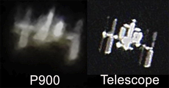
You can research these photos of the ISS, which flat-earthers will dismiss as being photoshopped; but they are dismissing many amateur astronomy buffs who have witnessed the ISS through optical telescopes.
This picture of the International Space Station was taken with a Nikon P900 by Mick West, about 83° above Shingle Springs, California, ISO 400, 1/250th, f/6.5. Manual focus. Handheld.
It’s not a great image, but the ISS is small compared to the moon, and it’s on the move.; but you can see how the shape matches up with those that are captured using a telescope.
You can find out when it’s going to be visible by subscribing the the NASA “Spot the Station” site, which can email you whenever there’s going to be a good flyover, or just give you a list of all upcoming times when it will be visible. https://spotthestation.nasa.gov/
This is the first attempt to capture the ISS without transiting either the sun or moon as background and which is most difficult given the lack of contrast presented by the daytime bright sky as well as the immense difficulty in achieving perfect focus. Although the Sun was used for focusing a few minutes earlier, the absence of sunspots aggravated the situation. The ISS was captured on two successive digital images spaced approximately 0.33 seconds apart and layered to form a single composite image. The ISS was moving from the bottom right to the upper left and, as suggested by the arrows in the annotated second image, transited (occulted?) the giant gas planet. http://www.perseus.gr/Astro-Sat-ISS-2010-05-29.htm
This image was taken as the ISS transits the Sun.
http://www.perseus.gr/Astro-Sat-Trans-2010-05-25.htm
This image was taken as the ISS transits the Sun.
http://astronomy.robpettengill.org/blog160904.html
This image was taken as the ISS transits the moon.
http://hotastronomy.com/amazing-shot-of-the-iss-transitting-the-moon/
The International Space Station arcs over the city of Annecy
https://astronomynow.com/2016/09/09/the-space-station-under-venus-and-the-moon-by-philippe-jacquot/
Here’s a list of the most tracked satellites from N2YO.com, which flat earthers have to dismiss, which means that people who use these satellites are all part of the cover up.
AGILE is an Italian gamma ray observatory launched aboard an Indian rocket today, beginning a three-year mission to survey the sky in a search for faraway sources of the Universe’s most energetic form of light.
ALOS (Advanced Land Observing Satellite), also known as Daichi, is a Japanese (JAXA) remote sensing craft that was launched by a H-2A rocket from Tanegashima Space Center at 01:33 UT on 24 January 2006.
AQUA (EOS-PM1) is an afternoon equator-crossing platform which includes a suite of sensors designed to study the diurnal properties of cloud and aerosol radiative fluxes, cloud formation, and precipitation (MIMR, AIRS/AMSU-A/MHS, and MODIS-N) in conjunction with a wind scatterometer planned for the Japanese ADEOS-II spacecraft.
COSMOS 2458 is a Glonass satellite, designed to last seven years broadcasting navigation signals to Russian military and civilian users.
The Electro-L satellite is Russia’s second high-altitude weather observatory, coming after a troubled mission launched in 1994 that never achieved all of its goals The next-generation Electro-L program faced years of delays because of interruptions in funding.
ELEKTRO-L 2 is a weather satellite to help civilian and military forecasters track storm systems, collecting near-realtime images of weather systems from Europe to the Asia-Pacific, joining an international fleet of geostationary weather satellites owned by the United States, Europe, India, China and Japan.
Express AM5 provides digital television and radio broadcasting, telephone, video conferencing, data transmission and Internet services.
FOX-1A is a small 1-Unit CubeSat developed by AMSAT.
GE-23 AMC 23, with a pre-launch name of Worldsat 3, is an American geostationary communications satellite that was launched by a Proton-M rocket from Baikonur at 02:28 UT on 29 December 2005.
GOES 13 is an American (NOAA) geostationary weather satellite that was launched by a Delta 4 rocket from Cape Canaveral at 22:11 UT on 24 May 2006.
GOES 15 (GOES-P) is an American weather satellite, which will form part of the Geostationary Operational Environmental Satellite (GOES) system operated by the US National Oceanic and Atmospheric Administration.
KANOPUS-V 1 The Canopus-B satellite, developed by the All-Russia Research Institute of Electromechanics (NPP VNIIEM), is designed for remote sensing of the Earth.
KMS 3-2 KWANGMYONGSONG 3 is a North Korean Earth observation satellite, which according to the DPRK is designed for weather forecast purposes, and whose launch is widely portrayed in the West to be a veiled ballistic missile test.
KMS-4 (Kwangmyongsong-4 meaning Bright Star-4 or Lodestar-4 in Korean) is an earth observation satellite launched by North Korea on 7 February 2016.
LANDSAT 8 The Landsat Data Continuity Mission (LDCM), a collaboration between NASA and the U.
METEOR M1 is a a Russian weather satellite designed to monitor the Earth’s climate.
METEOR M2 was designed to watch global weather, the ozone layer, the ocean surface temperature and ice conditions to facilitate shipping in polar regions and to monitor radiation environment in the near-Earth space.
METOP-A is Europe’s first polar-orbiting weather satellite and will give forecasters a new perspective on weather phenomena.
METOP-B is a 9,005-pound (4,085-kg) spacecraft outfitted with eight instruments to survey clouds, winds, moisture, greenhouse gases, and other atmospheric conditions for at least five years.
Navstar 57, also known as USA 183 and as GPS 2R-M1 (and as GPS 2R-14), was launched by a Delta 2 rocket from Cape Canaveral AFS at 03:37 UT on 26 September 2005.
NAYIF (EO-88) is a small satellite designed to send and receive messages on amateur radio frequencies.
NOAA 18 Polar-orbiting satellite; long-range weather forecasting; atmospheric and weather monitoring instruments; data stored on-board and transmitted over Fairbanks, AK and Wallops Island, VA.
NOAA-19 is the fifth in a series of five Polar-orbiting Operational Environmental Satellites (POES) with advanced microwave sounding instruments that provide imaging and sounding capabilities.
NPP NASA launched the National Polar-orbiting Operational Environmental Satellite System Preparatory Project, or NPP, on Oct.
NSS 12 was manufactured by Space Systems/Loral and has a 15-year design life the 12,400-pound (5,625-kg).
PARKINSONSAT (PSAT) is a 1 1/2 U CubeSat designed by the Naval Academy.
RESURS P1 is a Russian civil remote sensing satellite featuring a modernized high-resolution digital camera to collect imagery of Earth for Russian government agencies and international customers.
RESURS P2 is a Russian satellite to survey the globe and a plasma physics experiment to seek out signs of exotic antimatter and dark matter in the cosmos.
RESURS P3 is a Russian Earth observation satellite.
SAUDISAT 1C (or SO-50, Saudi-OSCAR 50) carries several experiments, including a mode J FM amateur repeater experiment operating on 145.
SENTINEL 2A, together with the other Sentinels, is gathering data for Europe’s Copernicus programme, which will provide accurate, timely & easily accessible information for environmental management, understanding climate change and assisting in disaster response.
SES 1 is a communications satellite designed to replace two aging spacecraft serving North America.
SPOT 7 is a commercial high-resolution optical imaging Earth observation satellite system operating from space.
TERRA The Earth Observing System (EOS) is a science and observation program that will provide long-term (15-year) data sets for Earth system science in order to gain an understanding of the interactions between Earth’s land, atmosphere, oceans, and biology.
THURAYA 2 Capacity for 13,750 simultaneous calls; voice, fax, data transmissions from/to mobile telephones; Middle East, North and Central Africa, Europe, Central Asia and the Indian subcontinent.
TIANGONG 1 is the first Chinese space laboratory module launched on a critical test flight to demonstrate the vital docking technology required for a future space station.
YAMAL 402 was supposed to maneuver itself into a circular geosynchronous orbit 22,300 miles (35,888 km) up and lowering inclination where it can match Earth’s rotation and appear parked over the equator at 55 degrees East longitude to begin a 15-year service life.
Additional information on satellites:
In radio communication, skywave or skip refers to the propagation of radio waves reflected or refracted back toward Earth from the ionosphere, an electrically charged layer of the upper atmosphere. Since it is not limited by the curvature of the Earth, skywave propagation can be used to communicate beyond the horizon, at intercontinental distances. It is mostly used in the shortwave frequency bands. https://en.wikipedia.org/wiki/Skywave
Digital Globe captures high-resolution imagery from their satellite, to provide information to a broad list of customers.
Satellite Imaging Corporation (SIC) was formed in the early 1990’s as a response to increasing demand for medium and high resolution 2D and 3D satellite image data.
Full-Disk HD Images of the Earth from Satellites
Geosynchronous vs Geostationary Orbit
why don’t you leave comments open on all pages so we can show you how weak your position is????
Wes, I thought that I had them all enabled in WordPress. I enable the two pages that didn’t have them enabled, so comment away with your weak explanations.
Flights
https://flatearthdeception.com/flights-prove-the-flat-earth-deception/
Water
https://flatearthdeception.com/ships-and-water-prove-the-flat-earth-deception-that-water-curves/
Elon is a fake. You probably believe a tesla is orbiting the earth because you saw a fake cgi pic. There are no satellites. They use balloons. They crash in yards and a balloon is always with it. There is no space station. Watch the bloopers on the space station. They use harnesses and their green screen glitches out often. All space is fake and you are spreading lies.
Wes, no, I don’t believe that there’s a Tesla orbiting the earth. Elon Musk serves the god of this world, and is promoting an evil agenda of AI and transhumanism.
I don’t cite NASA on my explanations, as they are a wicked organization that is used to promote heliocentrism and the evolution doctrine. No doubt they fake things like the moon landing, the Mars Rover pictures, etc.
Tus satélites….
http://www.intercomms.net/AUG03/content/struzak1.php
Martin, the article says that they’re an ‘alternative to the terrestrial and satellite telecommunication systems.’ It’s not proof that there are no satellites. We can track and view satellites travelling in a precise orbit, which proves that they’re not balloon satellites.
No, this is most definitely not true.
Satellites are high altitude balloons and not like in movies, some kind of machines in space. It would be pretty difficult above a spinning ball earth also?
This is not even a secret, Google “High Altitude Balloons NASA” (or “Satellites”) and you’ll see.
The Earth Is Flat. It’s the Truth.
Jonna, high altitude balloons can’t orbit above the earth in predictable patterns. A few weeks ago I watched what is reportedly the ISS travel across the Colorado sky in a perfectly straight line. That’s just not possible for a high altitude balloon. Search YouTube for videos about Elon Musk’s Starlink: SpaceX’s satellite internet project.
I don’t believe that the earth is spinning, so your point about that is without merit.