This website exposes the flat earth deception and proves that the earth is globe shaped.
This page discusses maps which prove that the earth is a globe, not flat.
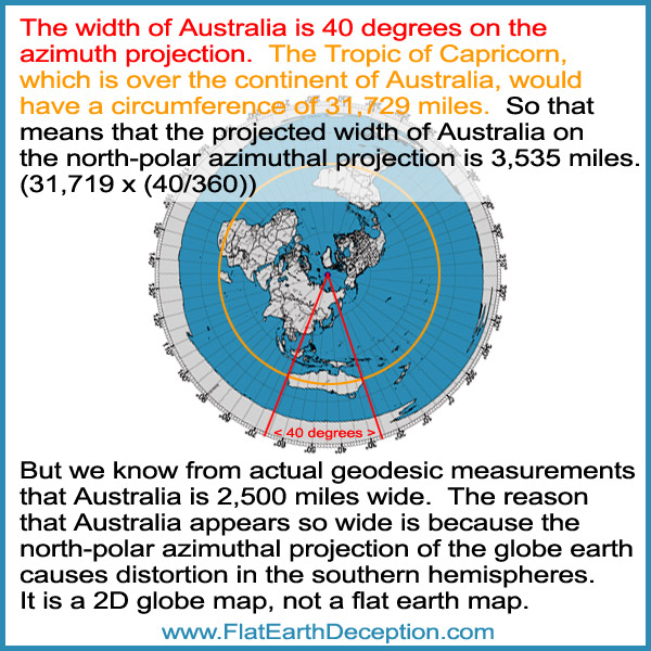
Question for flat earthers: How do you explain why the continent of Australia is distorted and appears to be 3,525 miles wide on the flat earth map, when we know from actual geodesic measurements that it’s 2,500 miles wide?
This is how the globe earth is rendered as a north-polar azimuthal equidistant projection.
They flare the globe out at the south pole. This is why the continent of Antarctica is radically distorted to look like a white ring.
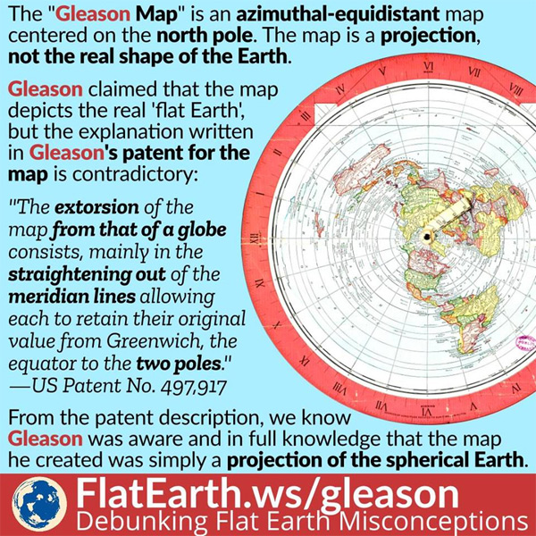
Flat Earthers cite the Gleason Map as a flat earth map, but Gleason knew that it’s a 2D representation of the globe earth.
Sunlight on the Gleason flat earth map does not work properly.
Two excellent videos that demonstrate clearly why the Geometry of Sun angles make no sense on a Flat Earth but always work perfectly on the Globe.
The continent of Australia appears to be really wide on the north-polar azimuthal projection, because it distorts the southern hemisphere. This proof alone proves that it is not a flat earth map, and that it is just a projection of the globe earth.
The map that flat-earthers use actually represents the globe earth!
It’s a north-polar azimuthal equidistant projection, also called an azimuthal map projection. These maps can be centered from anywhere, but the north pole is the most common reference point.
You can make them on this Azimuthal Map Generator website, you just need to define the center point with longitude and latitude.
This is centered on the North Pole:
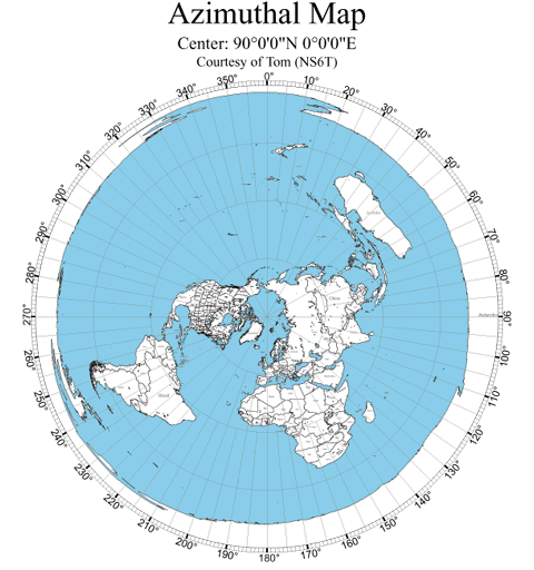
It is a projection of a globe earth onto a 2D map, that has straight meridian lines, with distances from the pole represented correctly.
It’s what you would see from the top of the globe earth, with the bottom hemisphere expanded out into the outer circles.
It’s not a proportionally correct map, as it exaggerates the size of countries in the southern hemisphere, as you can see with Australia, which is huge.
Australia is at the 45 degree south line, so on that map it’s twice the normal size.
If the bottom of the globe was water, then the edge of the map would have just been blue.
Since the continent of Antarctica is on the very bottom of the globe, the only way to represent it on a north-polar equidistant projection map is to spread it out around the outer circle, as all of the longitudinal (meridian) lines point down to it.
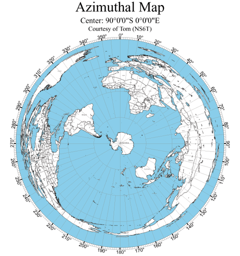
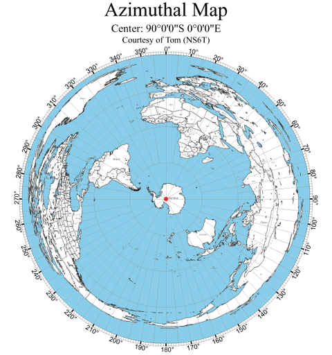
Here is one that is centered from the South Pole in Antarctica. You can see that the continents that are north of the equator are disproportionate. Note that Australia is correctly represented as it is close to Antarctica.
Here is one that is centered around the middle of the U.S., from Denver. Once again, the continents that are on the opposite side of the globe from the U.S. are disproportionately spread out in the outer circle.
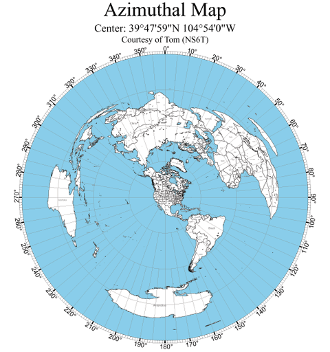
Now look back at the above projection maps that are based from the South Pole and America. Because there is no land mass directly opposite of the center point, there is no land ring on the outside of the circle. It is just ocean.
Now let’s look at the north-pole equidistant map again. As I previously noted, the white land mass that encircles the map represents the continent of Antarctica, which is distorted by the map being flared out.
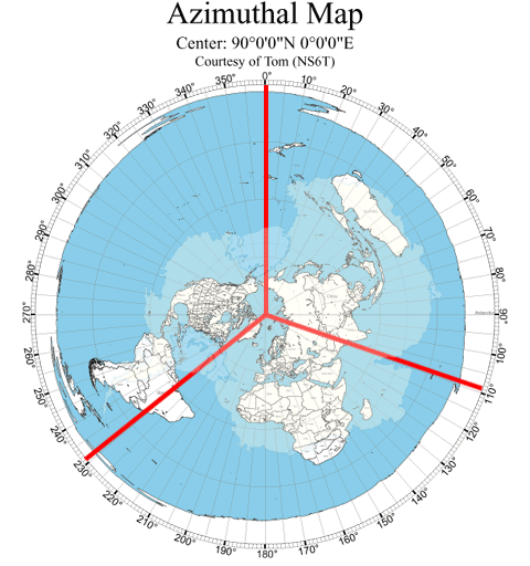
Every meridian line that originates from the North Pole runs down to the South Pole.
So on the north-polar azimuthal equidistant projection below, the red circle represents the South Pole, as all of the meridian lines connect from the North Pole to the South Pole.
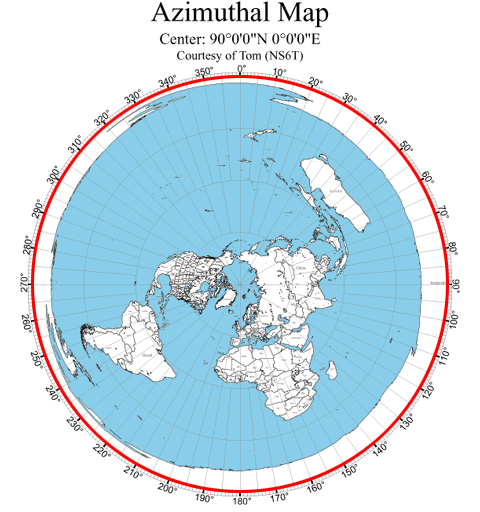
All of the meridian lines point down to the South Pole, which on this map is the red dot.
If you look at the land mass that encircles the azimuthal equidistant map projection, it is not uniform. The land mass is thicker on the right side. And there are some areas that are recessed.
That circular land mass is the continent of Antarctica spread out wide, and the .
Now look at this image that keeps the land mass around the outside edge, and has the continent of Antarctic in the middle, as that is what is on the bottom of the globe. The land mass is exaggerated, as the outside ring representation is exaggerated. The continent is inverted to match the inverted outer circle, as the equidistant view is from the top down.
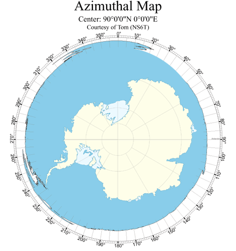
Look at the left side of the continent, which is small compared to the right side. That matches the thin land mass of the left, compared to the right.
Now look at the peninsula on the left lower side at 240 degrees. It matches the peninsula on Antarctica.
The top of the circle is very thin and has a recess.
That matches the curvature of the top of Antarctica.
On the bottom right at 110 degrees, there is a small indentation.
That matches the bay on the southeast part of Antarctica.
Let’s take it one step further. The bottom left red line shows that the meridian lines runs from the bay of Antarctica through South America. The bottom left red lines shows that the meridian line runs from the small bay runs through Asia. The top red line shows that the meridian line runs from the other large bay in between North America and Russia.
The azimuthal equidistant map projection is only a tool, to help determine distances and flight maps on a globe earth.
Every time a flat-earther posts an explanation about direct airplane flights that they say is wrong on a globe earth; they are using this equidistant map, which is a globe map.
This Air Map Of The World from 1945 tells the truth, that the north-polar azimuthal equidistant projection represents a globe.
Notice that it doesn’t have an ice wall! That is because they didn’t include the continent of Antarctica, because it is so greatly distorted.
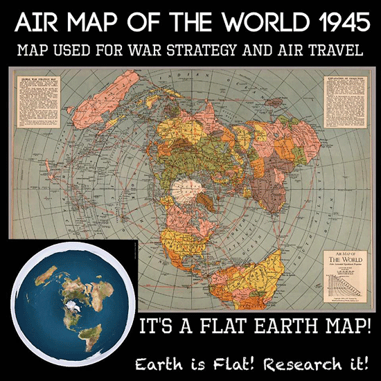
Here is the call out box on the top right:

It says “Since it is impossible to spread the surface of a globe on a flat surface without distortion, all maps are distorted in some respects. In this map the distortion occurs in the east and west distances. This distortion increases gradually from the North Pole to the Equator, and then quite rapidly to the outer limits. The distortion of the Antarctic areas would be so great that these are not shown.”
So they didn’t even include the supposed ‘ice wall’, because it’s not an ice wall; it’s the continent of Antarctica, which is greatly distorted by the algorithm used to make the projection map. Since Antarctica is opposite of the North Pole on the globe earth, the only way for the program to render it was to stretch it out as a circle. The outer circle is the South Pole. The continent has been inverted.
Flat earthers cite the Gleason’s New Standard Map Of The World as a flat earth map.
Alex Gleason wrote a book called “Is The Bible From Heaven – Is The Earth A Globe?’, in which he explains his flat earth theory.
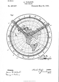
He applied for a patent for his map projection, which describes the map’s use as a time calculator for students. Here is what the patent image looks like, which has two hands on it, which spin around the north pole.
But the most important passage from his patent description is this:
“The map is not so extorted (distorted) as to lose the relative latitude and longitude of any places on the land or sea, but retains all latitudes and longitudes of places agreeing with other recognized authors; and as the proper relations of continents and countries all stand in their relative position to each other, they are thus impressed upon the mind of the student.”
Note: the words extorted and extorsion obviously mean distorted and distortion, as that makes sense when speaking about latitude and longitude on a projection map.
Alex Gleason is saying that the map projection has distortions; because is was derived from some other shape. That is what a north-polar azimuthal projection is, a projection of the 3D globe onto a 2D graphic.
“The extorsion (distortion) of the map from that of a globe consists, mainly in the straightening out of the meridian lines allowing each to retain their original value from Greenwich, the equator to the two poles.”
Alex Gleason proclaimed that it is a projection of a globe, which maintains the integrity of the meridian lines.
And note his phrasing “the equator to the two poles.” A flat Earth does not have two poles.
They cite that the U.N. mocks us by using a flat earth map.
Once again, it is simply a equidistant map, which represents the globe earth in a 2D format. How else would they, or anyone, represent the globe to show all of the continents in a 2D format?
Goofy flat earth explanations about Astronomy:
Here is their flawed explanation of the path of the International Space Station. There is no integrity with flat earth explanations like this. The map on the top is obviously not a good representation of a globe, as it’s a flat map with the countries side by side. The bottom image is a good representation of a globe, as it is a north-polar azimuthal equidistant projection map of the globe earth.
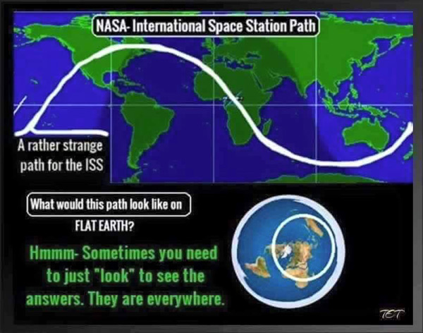
So they misrepresented the globe map, and then used a real globe map as supposed proof of the flat earth. Ya’ll need to wake up! The north-polar azimuthal equidistant projection map represents the globe earth. It is not a flat-earth map. By using that map you are proving the globe earth. Such irony!!!
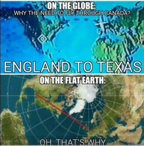
First of all, the image they use of the globe positions the two continents side by side, but they are on opposite sides of the globe, so it is a misrepresentation, which distorts the flight path going across the ocean. Of course, flight paths stay over land as much as possible for obvious reasons.
Then they use an equidistant map as their supposed flat earth map, to show the direct flight route. The anazimuthal equidistant map projection which shows distances and directions accurately from the center point. In this case, it shows the optimal flight path from England to Texas, which is direct and stays over land as much as possible.
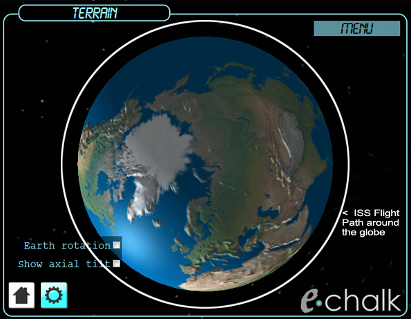
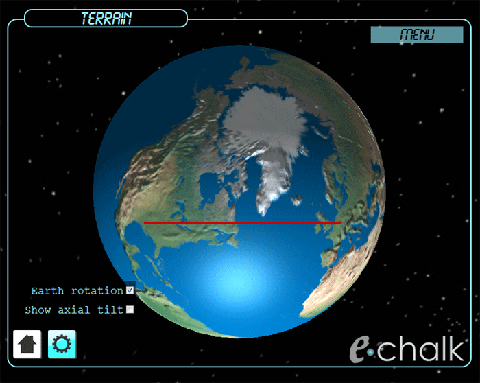
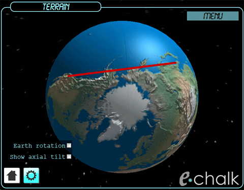
Here is the same flight path on a globe, which is the same as on the supposed flat earth map. You can use this echalk utility to see the direct flight path on the globe, which will match the equidistant map which the flat-earthers mistakenly use.
Here’s another example. Again the image on the left is a bad representation of a globe, and the image on the right is a globe equidistant projection map.
This all gets proved out with a picture of the flight on the globe earth
.
Flat earth believers make memes about flight paths using an equidistant map for their explanation. The irony is that is exactly what an equidistant map is for, as it represents the globe in 2D, to map out direct flights.
Here is a list of the types of map projections, of the globe earth.
A whole month and not a single response to my map challenge. Sad.
TJ
Flat earthers can’t ‘prove’ anything, they just know how to speak ‘flat earth talking points’, and attack those who believe that the earth is globe-shaped. It’s sad to watch.
I have thousands of hours in Scripture, though, it is not necessary to consult Scripture for the answer; and it is not relevant to the fact that flatearthers admit to not having an accurate map- I am just answering your question. Now, will you answer mine? Do you have a map or not? If not, why not? You do believe in maps don’t you? You are asking me to believe in the shape of our world. I am asking you to show me an accurate map of it. That is not an unreasonable request and, if the earth is really flat, it would be extremely easy to make such a map without consulting Scripture. Did we consult Scripture when we made a map of Africa, or the Americas? Did Australians consult scripture when they made a map of their continent? There is only one reason why there is no accurate map of it all together… it is impossible to accurately represent a globe on a flat map. This is why I propose the map challenge. It does not require Scripture or NASA or space travel or what the firmament is really like, etc.
The fact that there is no accurate map of the flat earth is itself evidence that the earth cannot be flat. If it were, it would be extremely easy to make a map and someone would have done it long ago. Don’t gloss over this point…. EXTREMELY easy! Will you show us an accurate map or give us a logical reason why someone hasn’t made one yet? I know you don’t have one, so, let’s just skip to the one single question I wish you would answer…
WHY IS THERE NO ACCURATE MAP OF THE FLAT EARTH?
TJ Jones
TJ Jones, and all those who feel the same, have you ever read the bible? Wonder if you even believe in such a thing…Bible tells it all “firmament”, the waters above, and the throne where God sits above the waters, other cultures describe the firmament as well, suppose they all sat down and devised this made up plan to write it in their history throughout the ages, not likely. Maybe the earth is not flat like a disc or a sheet of paper, but it surely isn’t a sphere! The firmament is most likely the sphere, and probably what has confused astronomers for centuries. Take the time to educate yourselves on something that the evil is trying to be destroyed, why are they trying to destroy true history, and Christianity? Because it is the truth.
If you would have clicked on the Biblical Proofs Of The Globe Earth page, you would have seen that most Scriptures that flat earthers cite are taken out of context; and the others may point to a geocentric globe earth, where the earth is fixed in space and not spinning.
Instead you just make accusations about whether we’ve read a Bible or believe in such a thing. SMH!
Hey Deez, just think about what you are saying… Why don’t they just show us pictures/videos??? Really??? You just said they should show us “actual snapshots” from “space stations.” The ISS is a space station. There is a live feed. I am asking you to step back and listen to what you are saying. You are trying to have it both ways. You suggest that all snapshots that exist of the globe earth are faked with “graphics and simulations.” At the same time, you say “Surely they should be able to show actual snapshots…” Can’t you see how this prevents any possibility of even having a debate? If I went to space myself, took a pic without a fish-eye lens and showed you, you would just turn right around and say I faked it. You are asking globeearthers to dismiss ALL the evidence while you insist on more evidence that you would just turn right around and dismiss anyway. Even if YOU went to space, found out it really is a sphere, and took a picture, all your fellow flatearthers will turn on you and say that you have betrayed them (and Yahweh) or that you have succumbed to possession by demons.
Unlike David, I would not ask you for photographic evidence of the flat earth, or dome, or edge, etc. I would not say you are wrong because you can’t afford a ticket to space to take the picture yourself. I will give you the possibility (no matter how small I think it to be) that all photos/videos from NASA and ALL sources are fake. I will even give you the claim that man never went to the moon. I will give you ALL your evidence except for one… A MAP. A map is the one thing that does not require space, NASA, moon landings, or curvature tests. Show me an accurate map of the flat earth and I will believe you. If you can’t show me a map, just give me a rational reason why one does not exist…. please.
TJ
Y’all silly! So you guys are debating over a map… the real question is why are there no real photos or video of the globe since we’ve been exploring outer space since the 60s. We have thousands of satellites orbiting our globe but not one appears in the composite image created to represent the globe model of earth. No real images just graphics and simulations. Surely if we’ve been to outer space with all these technology advanced cameras NASA should be able to show actual snapshots of the entire earth from on of our many satellites or space stations floating, I mean orbiting our globe.
It’s hilariously ironic that you ask for pictures of the globe, which have been provided from other sources other than NASA; but you have no pictures of the dome, no pictures from above the flat earth showing all of the continents, and no pictures of the edge of the flat earth where the dome hits the ground. 😛
I am not sure what you mean when you say they wouldn’t easily allow a true flat earth map. That makes no sense. If we have an accurate map of Africa and all the continents why can’t someone… anyone… just make a map of the whole thing? There is no logical reason why a flat map of the earth does not exist except for one… the earth is round.
TJ
If the people were being deceived by the powers that be, do you really think they would easily allow a true flat earth map? Leaving out religion, there are just too many observations being recorded that show distant objects, that globe maths state we should not be viewing.
Hey Peewee, just answer one question… why is there no accurate map of the flat earth?
Hello,
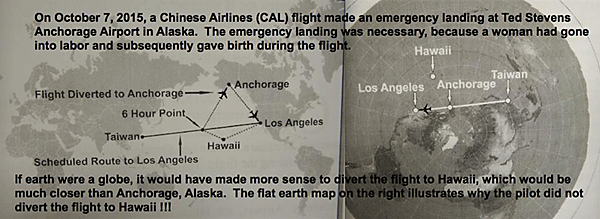
if you had checked the flight path fom los Angeles to Taipeh Taiwan on a real 3d Globe with proper tools, you would not have written as you did. Because one can clearly see that from a direct flight path, Anchorage is about 2 times as far from “the Flight Path” as Hawaii. Depending of where excactly the plane actually left its predestined path it would actually have been faster to simply fly back to LA thats about 1.8 times as Hawaii away measured from my choosen starting point to measure.
Try again, buy a cheap Globe Model . Cheers
Right on! Its evident that the globe earth is all wrong when it comes to flight paths. Common sense to take the most straight direct route. On a globe map it shows planes going in big curvatures to get to there destinations. Besides water lays flat, if the world was a globe all the ocean water be on the bottom. Gravity as been proven to not exist.. the government is definitely hiding what’s beyond the Antarctica. They try to brain wash us from an early age that there’s a globe earth . Only last 400 years we believed it. USA was in a rush to get to the moon when in reality they never landed on the moon in 1969. 49 years later they never tried to do a televised moon landing again. They play us for fools. The point is don’t believe what your told unless you seen it with your own eyes. Otherwise have doubt cause we all can’t be that dumb.
The southern hemisphere flight routes prove that the earth is a globe. http://flatearthdeception.com/flights-prove-the-flat-earth-deception/
Excellent job you are doing here, David! The more of us working to expose the lies of the Flat Earth movement, the better. The North Polar Azimuthal Equidistant Projection is accurate along the meridians of longitude. Distortion between meridians of longitude (in other words, along the parallels of latitude) begins as soon as you leave the dot that is the North Pole. This distortion increases as the distance from the North Pole increases.
Thank you for your comment Steinar! I try to do my part by providing simply, logical, provable points; to show that the earth is not flat. 🙂