
This website exposes the flat earth deception and proves that the earth is globe shaped.
This page provides proof that Antarctica is a continent on the bottom of the globe earth, not an ice ring that surrounds the flat earth.
Flat earthers show pictures of the supposed ice shelf that encircles the flat earth.
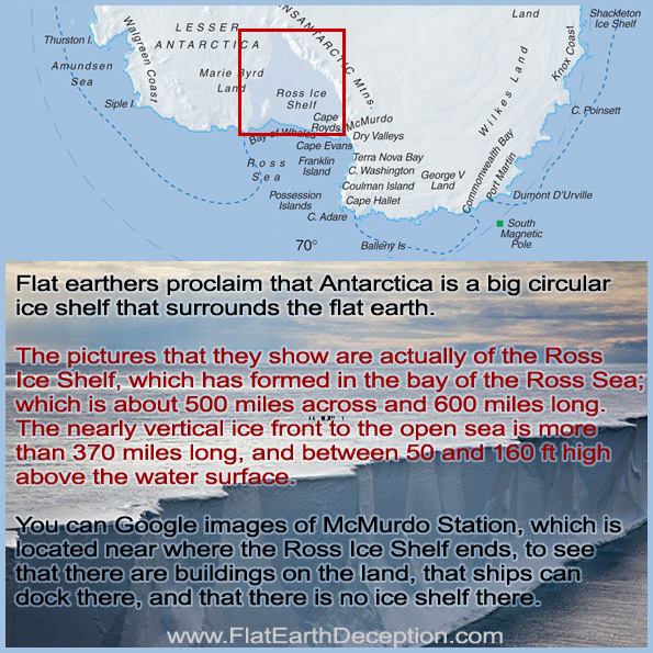
In reality, the pictures that they post are of the Ross Ice Shelf, which is the largest ice shelf of Antarctica, taking up an area of roughly 188,000 sq miles; about 500 miles across and 600 miles long; so it is about the size of France
The nearly vertical ice front to the open sea is more than 370 miles long, and between 50 and 160 ft high above the water surface.
The continent of Antarctica is circumnavigated as a boating race coarse.
Yachting legend Jon Sanders was the first man to circumnavigate Antarctica, circling the continent twice in 1981 – 1982.
During the voyage, he passed south of the three great capes: Horn, Good Hope and Leeuwin, before rounding Cape Horn a second time. He turned north to Plymouth, UK and returning south around Good Hope and returning to Fremantle.
This voyage was recognized in the Guinness Book of Records through the following records:
- The first single-handed sailor to remain continuously at sea twice around the world
- First single-handed sailor to round the five southern most Capes twice on one voyage
- First single-handed sailor to round the five southern most Capes twice
- Longest distance continuously sailed by any yacht: 48,510 miles (78,070 km).
- Longest period alone at sea during a continuous voyage: 419 days: 22 hours: 10 minutes
This proves that Antarctica is a continent that is capable of being circled. Sailing around the ice wall of the flat earth would have taken way more time.
The Antarctica Cup Race proves that it is a continent.
This event is a non-stop race of circumnavigating Antarctica, passing the three most notorious capes on the planet Cape Leeuwin, Cape Horn, Cape Agulhuss.
The record time is 102 days 00 hours 56 minutes 50 seconds for this 16,400 mile circuit of Antarctica.

Obviously if they were sailing around the supposed ice wall on the flat earth, they would be traveling a much longer distance; as flat earthers estimate that it would be 70,000 – 78,000 miles.
Mike Horn sailed to Antarctica, then kited to the south pole, then to the Australia side of the continent.
After 57 days solo, Mike reached the Dumont d’Urville station on the other side of Antarctica, becoming the first person to complete this 5,000km traverse.
Antarctic Logistics and Expeditions is the sole provider of logistic support and safety backup for climbing expeditions to Mt. Vinson, the highest peak in Antarctica.
Working in the world’s coldest environment, the mechanics at ALE operate and maintain everything from snowmobiles to turbo-prop planes to the tracked passenger vans that shuttle climbers from the blue ice runway to Union Glacier Camp.
Flat Earthers say that they don’t have pictures of the end of the ice wall and dome, because of the Antarctic Treaty; and that the military keeps people out.
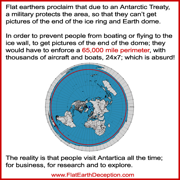
Flat earthers proclaim that nobody can visit Antarctica, but many people do that every year; including who take the Antarctica Sightseeing Flight.
The people who travel to or live in Antarctica fall into two main groups, those who live and work on scientific research stations or bases, and tourists.
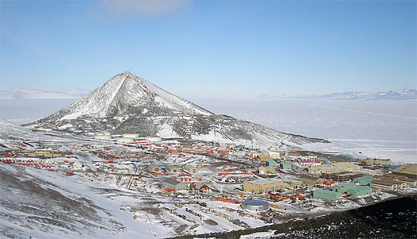
Here is a helicopter view of McMurdo Station, Antarctica. Facing the mountains across the Ross Sea, the helo rises, turning toward the helipad, the Crary Lab (three white buildings connected by ramp), the blue dining hall with dorms, fuel storage tanks (round white things), windmills above Scott Road; then a brief view of volcano Mount Terror, heading out across Ross Sea. Mount Discovery appears, then the Royal Society Range (I think). Then a long stretch of sea ice, ending with a giant flat iceberg.
Here are pictures of Villa Las Estrellas, showing that Antarctica is not just an impassable ice shelf.
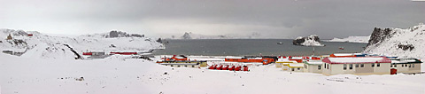
Here is a photo of Villa Las Estrellas from above.
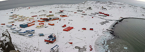
There are around 66 scientific bases in Antarctica, of which about 37 are occupied year round. There are about 4,000 people through the summer months and about 1,000 overwinter each year.
Here is McMurdo Base.
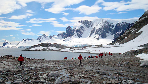
Here’s a picture of tourists exploring Antarctica.
Source: http://www.coolantarctica.com/Antarctica%20fact%20file/science/can_you_live_in_antarctica.php
You can see more pictures of McMurdo Base – Antarcticans Database Project
http://www.coolantarctica.com/Bases/McMurdo/thumbs1.php
The South Pole Station
http://www.coolantarctica.com/Bases/South_Pole/thumbs4.php
Antarctica Travel
http://www.coolantarctica.com/Travel/antarctic_peninsula.php
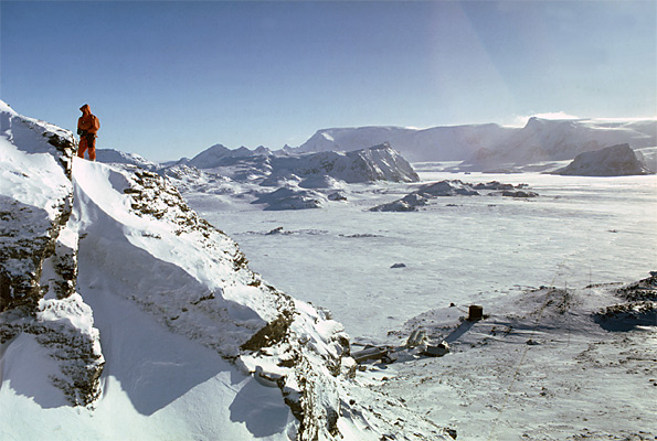
Antarctica Mountains
http://www.coolantarctica.com/gallery/scenic/gallery-mountains-thumbnails.php
Falt-earthers say that if people try to visit Antarctica, they will be met with resistance by the military.
Apparently someone forgot to tell these people who had adventures there.
You can book flights to Antarctica
http://www.swoop-antarctica.com/cruises/flights
You can go an Antarctica Cruise and Adventure Travel With Cool Antarctica and Expedition Trips
http://www.coolantarctica.com/Travel/Fly_to_Antarctica.php
Quark Expeditions has been the world leader in polar cruises and guided tours for over two decades and successfully operated many first-ever passenger trips to Antarctica, including the Circumnavigation of the Antarctic continent and the first Weddell Sea voyage.
Here are links to more videos proving that people visit and explore Antarctica:
Antarctica Cruise – Visiting The Antarctica Peninsula https://youtu.be/wEKDAgytQcw
Antarctica Adventures with the Best Cruise Ship Ever Built https://youtu.be/s6pXARR4vdA
Expedition cruise to Antarctica with Polar Star Expeditions https://youtu.be/2zEJapASyyU
Want to travel to Antarctica? https://youtu.be/snYw2Y6L0g8
Antarctica, Secrets Beneath the Ice | Full Documentary HD https://youtu.be/XeJiuWkBWzw
Under the Antarctic Ice Beauty of The Nature 720p Documentary https://youtu.be/1NlxeJQ4abI
Is An Ancient City Hidden Under Antarctica? https://youtu.be/KaSGbZ8y8FA
The Amundsen–Scott South Pole Station is a United States scientific research station at the Geographic South Pole, the southernmost place on the Earth.
Antarctic related mapping resources prove that it is a continent:
- BAS Map Catalogue — a selection of maps published by BAS, with ordering information
- Antarctic Digital Database (ADD) — the premier source of vector topographic data for Antarctica
- British Antarctic Territory Gazetteer — list of all approved names for British use within the British Antarctic Territory
- South Georgia GIS — Web-based visualisation tool for South Georgia and the South Sandwich Islands spatial data, funded by the South Georgia Government (GSGSSI). Downloads of datasets available to South Georgia science community (free registration required)
- SCAR Map Catalogue – A catalogue of Antarctic region maps produced by SCAR member countries
- SCAR Geoscience Map Catalogue – A listing of all geoscientific maps of Antarctica
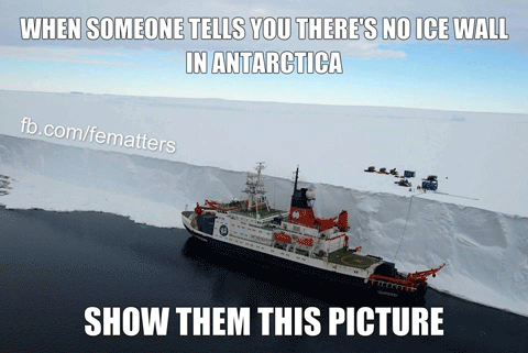
Flat earthers post images like this, that show the thick ice shelf of Antarctica, and imply and that it is an ice ring that encircles the Earth.
.

Are there places like this on Antarctica? Yes. Is all of Antarctica like this? No.
He seems to make a big deal out of ships that have sails, like that means something significant.
And he’s right. In order to keep Antarctica pristine and not risk pollution from motorized ships, in some of the places they use sailing ships.
On Flat Earth Deception home page you saw that flat-earther are using an north-polar azimuthal equidistant map, which shows the globe earth on a 2D projection. The Southern hemisphere is flared out to make it visible, which greatly exaggerates the size of the southern continents such as Australia.
The only way to represent the continent of Antarctica is to project is as a ring, because all of the longitudinal lines point down to it.
When asked for pictures of the edge of the flat earth, they proclaim that Antarctica is protected so that nobody can see the edge of the supposed dome.
So they dismiss any image from space, but they have no photos to prove that Antarctica encircles the flat earth, or that there is an edge to the supposed dome.
So until they produce pictures of the end of the supposed ice rings, we’ll have to trust these pictures from people are not involved in the flat earth discussion.
Additional resources that prove that Antarctica is a continent, not an ice ring:
50 Years of Antarctic Research Expeditions by the Geographical Survey Institute
Here’s a list of Antarctic expeditions is a chronological list of expeditions involving Antarctica, and NO ICE WALL OR GLASS DOME WAS REPORTED.
- 1907 — 1909 Nimrod Expedition – On 9 January
- 1909, Ernest Shackleton reached 88’23S (Farthest South), and on 16 January 1909, Professor Edgeworth David reached the South Magnetic Pole at (72°25’S 155°16’E? / ?72.417°S 155.267°E? / -72.417; 155.267) (mean position)
- 1908 — 1910 Fourth French Antarctic Expedition – led by Jean-Baptiste Charcot
- 1910 — 1912 Japanese Antarctic Expedition – led by Nobu Shirase
- 1910 — 1912 Roald Amundsen’s South Pole expedition – On 14 December 1911, reached the South Pole (90° S)
- 1910 — 1913 Terra Nova Expedition – On 17 January1912, Robert Falcon Scott, reached the South Pole (90° S)
- 1928 — 1930 Richard Evelyn Byrd – First expedition
- 1931 H Halvorsen – discovered Princess Astrid Coast
- 1931 Hjalmar Riiser-Larsen – flew over Antarctica, discovered Kronprins Olav Kyst
- 1933 — 1935 Richard Evelyn Byrd – Second expedition
- 1933 — 1939 Lincoln Ellsworth – Aircraft expedition
- 1934 — 1937 British Graham Land Expedition
- 1936 Lars Christensen – dropped Norwegian flag over Prince Harald Coast
- 1938 Third German Antarctic Expedition (New Swabia, or Neuschwabenland, claimed for Nazi Germany) – led by Alfred Ritscher
- 1939 — 1941 United States Antarctic Service Expedition – led by Richard Evelyn Byrd
- 1943 — 1945 Operation Tabarin – led by Lieutenant James Marr
- 1946 — 1946 Operation Highjump – led by Richard Evelyn Byrd
- 1947 — First Chilean Antarctic Expedition
- 1947 — 1948 Operation Windmill – led by Commander Gerald Ketchum
- 1947 — 1946 Ronne Antarctic Research Expedition – led by Finn Ronne
- 1949 — 1952 Norwegian-British-Swedish Antarctic Expedition – led by John Giaever
- 1955 — 1956 Operation Deep Freeze – led by Richard Evelyn Byrd
- 1955 — 1957 1st Soviet Antarctic Expedition — led by Mikhail Somov
- 1956 Amundsen-Scott South Pole Station established
- 1956 — 1958 Commonwealth Trans-Antarctic Expedition – led by Vivian Fuchs
- 1956 — 1958 2nd Soviet Antarctic Expedition — led by Aleksei Treshnikov
- 1957 — 1958 International Geophysical Year
- 1957 Scott Base established
- 1957 — 1958 Luncke Expedition
- 1957 — 1959 3rd Soviet Antarctic Expedition — led by Yevgeny Tolstikov
- 1958 — 1960 4th Soviet Antarctic Expedition — led by Aleksandr Dralkin
- 1959 — 1961 5th Soviet Antarctic Expedition — led by Yevgeny Korotkevich
- 1960 South African National Antarctic Expedition
- 1960 — 1962 6th Soviet Antarctic Expedition — led by V.Driatsky
- 1961 — 1963 7th Soviet Antarctic Expedition — led by Aleksandr Dralkin
- 1962 — 1962 Vostok traverse – led by Australian National Antarctic Research Expeditions (ANARE)
- 1962 — 1964 8th Soviet Antarctic Expedition — led by Mikhail Somov
- 1963 — 1965 9th Soviet Antarctic Expedition — led by Mikhail Somov
- 1964 — 1966 10th Soviet Antarctic Expedition — led by M.Ostrekin, I.Petrov
- 1965 — 1967 11th Soviet Antarctic Expedition — led by D.Maksutov, Leonid Dubrovin
- 1966 — 1968 12th Soviet Antarctic Expedition — led by Pavel Senko and Vladislav Gerbovich
- 1967 — 1969 13th Soviet Antarctic Expedition — led by Aleksei Treshnikov
- 1968 — 1970 14th Soviet Antarctic Expedition — led by D.Maksutov, Ernst Krenkel
- 1969 — 1971 15th Soviet Antarctic Expedition — led by Pavel Senko and Vladislav Gerbovich
- 1970 — 1972 16th Soviet Antarctic Expedition — led by I.Petrov and Yury Tarbeyev
- 1971 — 1973 17th Soviet Antarctic Expedition — led by Yevgeny Korotkevich, V.Averyanov
- 1972 — 1974 18th Soviet Antarctic Expedition — led by Pavel Senko
- 1973 — 1975 19th Soviet Antarctic Expedition — led by D.Maksutov, V.Ignatov
- 1974 — 1976 20th Soviet Antarctic Expedition — led by V.Serdyukov, N.Kornilov
- 1975 — 1977 21st Soviet Antarctic Expedition — led by O.Sedov, G.Bardin
- 1976 — 1978 22nd Soviet Antarctic Expedition — led by N.Tyabin, Leonid Dubrovin
- 1977 — 1979 23rd Soviet Antarctic Expedition — led by V.Serdyukov, O.Sedov
- 1978 — 1980 24th Soviet Antarctic Expedition — led by A.Artemyev, O.Sedov
- 1979 — 1980 25th Soviet Antarctic Expedition — led by N.Kornilov, N.Tyabin
- 1980 — 1981 Transglobe Expedition – led by Ranulph Fiennes
- 1980 — 1982 26th Soviet Antarctic Expedition — led by V.Serdyukov, V.Shamontyev
- 1981 — 1983 27th Soviet Antarctic Expedition — led by D.Maksutov, R.Galkin
- 1982 — 1984 28th Soviet Antarctic Expedition — led by N.Kornilov, A.Artemyev
- 1983 — 1985 29th Soviet Antarctic Expedition – led by N.Tyabin, L.Bulatov
- 1984 – 1987 In the Footsteps of Scott – led by Robert Swan
- 1984 – 1985 1st Uruguayan Antarctic Expedition – Antarkos I Led by Lt.Col. Omar Porciúncula
- 1984 — 1986 30th Soviet Antarctic Expedition – led by D.Maksutov, R.Galkin
- 1985 — 1987 31st Soviet Antarctic Expedition — led by N.Tyabin, V.Dubovtsev
- 1986 — 1988 32nd Soviet Antarctic Expedition — led by V.Klokov, V.Vovk
- 1987 Iceberg B-9 calves and carries away Little Americas I – III
- 1987 — 1989 33rd Soviet Antarctic Expedition — led by N.A.Kornilov, Yu.A.Khabarov
- 1987 — 1988 First Bulgarian Antarctic Expedition — St. Kliment Ohridski Base established
- 1988 — 1990 34th Soviet Antarctic Expedition — led by S.M.Pryamikov, L.V.Bulatov
- 1989 — 1991 35th Soviet Antarctic Expedition — led by V.M.Piguzov
- 1991 — 1992 36th Soviet Antarctic Expedition — led by Lev Savatyugin
- 1996 Lake Vostok discovered
- 2004 – 2005 Tangra 2004/05 created Camp Academia.
- 2004 – 2005 AGASEA/BBAS joint U.S.-U.K. aerogeophysical survey of the Amundsen Sea Embayment.
- 2005 Ice Challenger Expedition travelled to the South Pole in a six-wheeled vehicle.[1]
- 2005 – 2006 Spanish Trans-Antarctic Expedition, led by Ramon Larramendi, reached the Southern Pole of Inaccessibility using kite-sleds.[2]
- 2007 – 2008 Norwegian-U.S. Scientific Traverse of East Antarctica.[3]
- 2008 – 2009 Impossible 2 Possible (i2P) unsupported South Pole quest by Ray Zahab, Kevin Vallely and Richard Weber.
Hey Pierre,
Your evidence is very weak. If the Earth is flat, please show us a map. You don’t have to include Antarctica. Just a simple map from the N. Pole to the tips of S. America and Africa, including Australia. You won’t be able to do it and there is a reason… the Earth is not flat.
It seem you didn’t see the Werner Von Braun grave. The Psalms 19:1 is wrote on it.
Here is the Psalms 19:1
1 The heavens declare the glory of God; and the firmament (raqiya in Hebrew) sheweth his handywork.
Raqiya = masculine noun
Root Word (Etymology)
From רָקַע (H7554)
KJV Translation Count — Total: 17x
The KJV translates Strong’s H7549 in the following manner: firmament (17x).
1. extended surface (solid), expanse, firmament
1. expanse (flat as base, support)
2. firmament (of vault of heaven supporting waters above)
1. considered by Hebrews as solid and supporting ‘waters’ above
Strong’s Definitions
רָקִיעַ râqîyaʻ, raw-kee’-ah; from H7554; properly, an expanse, i.e. the firmament or visible arch of the sky:—firmament.
Werner Von Braun was a aerospace engineer and space architect; who loved that the heavens declare the glory of our Creator. It is not a proof that the earth is flat, just another example of how flat earthers manipulate everything to try to reinforce their theory.
You added in your explanation to the Strong’s definition, to make it seem like it’s pointing to a flat earth; when it is really just pointing to the expanse of space.
raqiya` raw-kee’-ah from 7554; properly, an expanse, i.e. the firmament or (apparently) visible arch of the sky:—firmament.
If you’ve ever flown in a plane it’s very clear to see and for those that can’t get into the sky go to the ocean take binoculars with you and watch a boat you’d only disappears from your eyesight it doesn’t go over a curve it’s just your eyes can’t see that far but if you keep using a more high-powered telescope you will continue to see the boat travel for hundreds and hundreds of nautical miles with no curvature
All you have to do is enter the altitude of the plane into the earth-curvature formula, and it tells you that the horizon line appears hundreds of miles away; so of course you would be able to see a boat that is hundreds of miles away. At an altitude of 35,000 feet, the horizon line appears at 229 miles. Your statement proves nothing.
Furthermore, don’t take my word for it. I certainly cannot overrule Scripture. The only possibility is that your interpretation of Scripture is incorrect. I can only assume you are capable of reason and logical thinking. If Earth was flat, it would be extremely easy to make a map of it. Answer one simple question… Why is there no accurate map of the flat Earth?
New Challenge! If you can’t show us a map, just give a believable reason as to why not.
TJ
I wonder what the scripture in Isaiah 40 verse 22 talks about the Circle of the Earth meaning to me a round earth
Roy, I explain the proper context of Isaiah 40:22 on the Biblical Proofs Of The Globe Earth page.
A sphere is circular. Remember, there is no such thing as a circle. A two-dimensional circle does not exist in our three-dimensions. When we use a pencil to draw a circle on a piece of paper, the only reason we can see it at all is because, as tiny as it may be, the lead has height and the paper itself has height. For instance, what we Americans refer to as a 8″ x 11″ sheet of papers is really 8.5″ x 11″ x .004″. (Or, 216mm x 279.4mm x .01mm.) The thicker the paper (or weight) this higher the last number. Therefore, if Yahweh drew a circle, it was three-dimensional. A sphere is a three-dimensional circle.
Hey Truthseeker, it is NOT possible to see a boat with a telescope for hundreds of nautical miles while standing on the shore line. If it were someone would have already posted a video of it on YouTube. Can you prove what you are claiming or provide a link that does?
TJ
Hey Truthseeker, you getting email alerts? Any proof of your claim? I can see I am wasting my time here because you guys make outlandish comments then disappear.
TJ
David, TJ or Anyone
I have to admit a few months ago I was amazed by all this flat earth talk. The pictures, the military protection and especially the biblical background all caought my attention. I looked for more pictures of this ice wall and wondeedr how could something so abcious be kept a secret from Billions of people. I watched more videos “proving “ flat earth than I care to admit. I had one theory, with absolutely no way to back it up, that maybe all the distances that we say we know are not correct. Like the distance NASA says it is to the moon or the circumference of the earth. Lots of the mathematical problems flat earthers use to prove their theory is about the curvature of the earth. Do you have any LINC’s explaining the visual distances we can see at Sea Level that seem to dispute the curvature? Thank you for the website. It was very informative and answered a lot of questions.
Thank you for your comment Shane! That’s a great question about whether we’ve been deceived about the distances, but people determined the distance to the moon using geometry, long before NASA existed.
Flat earthers misapply the earth curvature formula as they don’t understand that it’s based on the horizontal line of looking straight out, not the horizon line.
You can see explanations on the Perspective Proves The Flat Earth Deception page.
Flat earthers zoom in on ships that are located 1-2 miles out, and pretend that there’s no curvature; but that’s not far out enough to see the curvature. They need to try to zoom in on cameras that are further out, like 10 miles out. They will proclaim that they can’t because of perspective, but that is a false association, as objects on the flat earth model cannot be hidden by the horizon.
Wolfie6020 on YouTube has a lot of great videos using high-tech cameras and equipment, which proves that the earth is not flat. I hope that helps! 🙂